Rhineland-Palatinate

30.062025 – Lahn valley perspectives near Balduinstein
Nestled between gentle river curves, forested hills and medieval stonework, Balduinstein is a hidden gem of the upper Lahn Valley.
This gallery captures the region from above and within: the ruins of Balduinstein Castle, the quiet village in the valley, peaceful railway lines along the Lahn, and the shifting light that transforms the landscape with every hour of the day.
N50° 20.666′ E7° 58.2
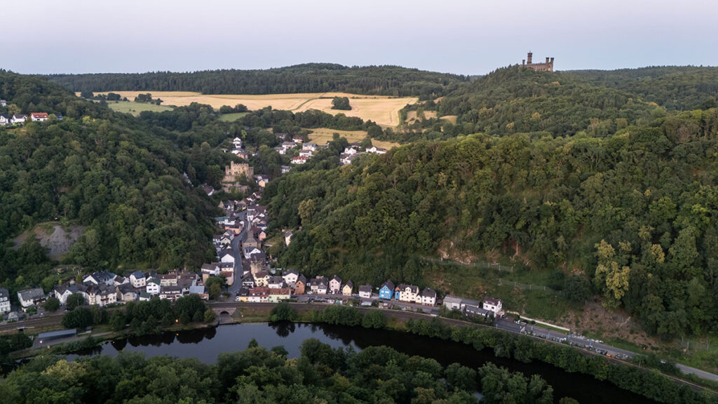
30.06.2025 – Schaumburg
50° 20′ 20.4″ N, 7° 58′ 39″ E |
30.06.2025 – Kloster Arnstein
N50° 18.620′ E7° 51.099′
30.06.2025 – Weinberge Obernhof
N50° 19.150′ E7° 51.250′
01.07.2025 – Schloss Nassau
N50° 18.653′ E7° 47.536′
01.07.2025 – Dausenau
N50° 19.719′ E7° 45.695′
01.07.2025 – Lahnstein
N50° 18.413′ E7° 38.666′
01.07.2025 – Schloss Stolzenfels
N50° 18.180′ E7° 35.523′
01.07.2025 – Burg Lahneck
N50° 18.377′ E7° 36.748′
01.07.2025 – Martinsschloss
N50° 17.852′ E7° 36.333′
01.07.2025 – Mainz
N50° 00.000′ E8° 16.267′
08.07.2025 – Worms
N49° 37.810′ E8° 21.587′
09.07.2025 – Wonnegau – Westhofen
N49° 42.267′ E8° 14.883′
09.07.2025 – Altrheine und Baggerseen bei Speyer
N49° 20.636′ E8° 27.082′
10.07.2025 – Speyer
N49° 19.032′ E8° 26.460′
10.07.2025 – Schloss Villa Ludwigshöhe
N49° 16.614′ E8° 05.258′
10.07.2025 – Burg Trifels
N49° 11.797′ E7° 58.668′
10.07.2025 – Deutsches Weintor
N49° 03.117′ E7° 57.391′
11.07.2025 – Steinerner Tisch
N49° 05.262′ E7° 55.148′
11.07.2025 – Burg Berwartstein
N49° 06.499′ E7° 51.768′
11.07.2025 – Teufelstisch
N49° 11.697′ E7° 44.631′
15.07.2025 – Rochuskapelle Bingen
N49° 57.996′ E7° 55.576′
15.07.2025 – At the Binger Loch
N49° 58.470′ E7° 52.350′
17.07.2025 – Zwei-Burgen-Blick
Schloss Burg Rheinstein N49° 59.614′ E7° 51.504′
Burg Reichenstein N50° 00.305′ E7° 51.212′
Clemenskapelle N50° 00.160′ E7° 51.339′
17.07.2025 – Loreley
N50° 08.355′ E7° 43.723′
17.07.2025 – Oberwesel
N50° 06.459′ E7° 43.623′
17.07.2025 – Burg Pfalzgrafenstein
N50° 04.988′ E7° 45.932′
17.07.2025 – Bacharach
N50° 03.559′ E7° 46.133′
19.07.2025 – Steckeschläferklamm
N49° 58.815′ E7° 49.659′
19.07.2025 – Burg Rheinstein
N49° 59.614′ E7° 51.504′
20.07.2025 – Schloss Rheinfels
N50° 09.220′ E7° 42.353′
20.07.2025 – Wasserfall bei St. Goar
N50° 08.223′ E7° 43.322′
20.07.2025 – Burg Katz
N50° 09.108′ E7° 43.449′
20.07.2025 – Burg Maus
N50° 10.313′ E7° 41.760′
21.07.2025 – Marksburg
N50° 16.314′ E7° 38.931′
21.07.2025 – Koblenz
N50° 21.400′ E7° 35.633′
22.07.2025 – Rolandsbogen
N50° 38.433′ E7° 12.133′
25.07.2025 – Dreimühlen-Wasserfall
N50° 19.490′ E6° 46.144′
25.07.2025 – Eifel-Impressionen
N50° 23.667′ E6° 57.995′
25.07.2025 – Nürburgring
N50° 20.134′ E6° 56.855′
25.07.2025 – Hohe Acht
N50° 23.168′ E7° 00.662′
25.07.2025 – Genoveva-Höhle
N50° 22.353′ E7° 13.043′
26.07.2025 – Kloster Maria Laach
N50° 24.136′ E7° 15.126′
26.07.2025 – Monreal
N50° 18.000′ E7° 09.567′
26.07.2025 – Burg Elz
N50° 12.300′ E7° 20.200′
27.07.2025 – Bopparder Rheinschleife
N50° 14.648′ E7° 34.345′
28.07.2025 – Winningen an der Mosel
N50° 18.883′ E7° 31.133′
29.07.2025 – Burg Thurant
N50° 14.908′ E7° 27.157′